


Relief Maps trek route planner app for iPhone and iPad
Developer: Batiste Vonderweidt
First release : 20 Jan 2019
App size: 270.74 Mb
Explore the great outdoors with our app - Relief Maps Trek Route Planner.
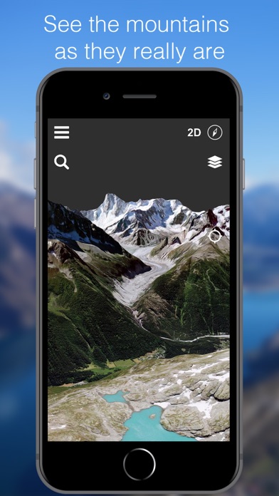
This leading-edge mapping tool places a 3D mountain GPS right in the palm of your hand for an immersive adventuring experience.
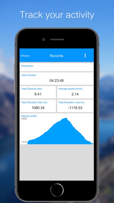
From mountain forecasts to live tracking of routes and terrain data, this terrain-focused application supports backcountry exploration, skiing, camping or just a nature trial.
Revel in the John Muir or pct trails, with GPS location and altitude log, neatly consolidated in real-time.
The app features slope angle shading, providing a minute understanding of the terrain before heading into the great wide open.
Plan your adventure with the inbuilt route planner, allowing you to understand the expected terrain of your path whether its on a hiking trail or riding a backcountry slope. The integrated graphic representation of landscapes enables a unique 3D viewing and understanding experience.
For hiking enthusiasts, our live tracking feature offers an unparalleled safety net. When you embark on a trek, the real-time tracking tool gives you the confidence to explore with ease. Your journey, whether its a simple trail walk or an ambitious mountain climb, is tracked live, enabling your loved ones to monitor your progress and exact location from the convenience of their homes. In case of an emergency or if you find yourself off the beaten path, the live tracking feature has you covered. It serves to ensure your safety, making it an essential companion for any hiking adventures.
The app provide detailed avalanche slope maps, a unique and safety-oriented feature for adventurers. It doesnt monitor and alert about potential avalanches, but rather assists users in understanding the contours and inclines of avalanche-prone slopes, enabling pre-planned, safe expeditions.
This app is a must-have tool for those constantly on the go or for the weekend warriors, searching for a new terrain or trail to conquer. Along with USGS maps, the application is handy whether you are planning on a trek, ski adventure, or youve holed up in a bivy gazing at the stars.
With Relief Maps Trek Route Planner, your adventures are amplified with calculated risks and measured fun, right at your fingertips. Start exploring today!
----
In-App Subscriptions:
Relief Maps offer auto-renewing premium subscriptions.
All our subscriptions will grant you an access to the offline maps features.
We currently offer a single description :
- Premium (€50.0/year) Gives access to all premium features: route planning and recording, route tracking and offline maps
These prices are for French customers but may vary by country or when converted to local currency.
Subscriptions will be charged to your credit card through your iTunes account. Your subscription will automatically renew unless canceled at least 24 hours before the end of the current period. You will not be able to cancel the subscription once activated. You can manage your subscriptions in your itunes account settings after purchase. Your subscription will automatically renew at the end of each renewal period and you will be charged through your iTunes account. Any unused portion of a free trial period, if offered, will be forfeited when the user purchases a subscription to that publication.
Terms of use: https://reliefmaps.io/terms.html
Privacy policy: https://reliefmaps.io/privacy.html